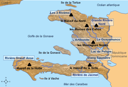
Although this map is in French with Haiti's given mountain names, in looking at this map we get an idea of where Haiti's mountains are located. The highest peak is located in the le Selle mountains and measures 8,793 feet.
(No Author) [Untitled] (2010). Retrieved from (http://www.hpfe.net/haiti.html)
(No Author) [Untitled] (2010). Retrieved from (http://www.hpfe.net/haiti.html)

This map gives us an insight into where the major rivers of Haiti are located.
(No Author) [Haiti River Map] (2010). Retrieved from (http://www.mapsofworld.com/haiti/river-map.html)
(No Author) [Haiti River Map] (2010). Retrieved from (http://www.mapsofworld.com/haiti/river-map.html)

This map shows the three regions of Haiti.
Northern Haiti is shown in red and contains many large cities, aside from the capital, as well as tourist destinations including beaches (Cape Haitien).
Central Haiti is shown in green and contains the most dense population of the three regions including the capital city of Port-au-Prince.
Southern Haiti is shown in purple and is considered the most rural of the three regions. This region also includes popular sites for backpacking like Jacmel and Port-Salut.
(Fitzgerald, Peter) [Haiti regions map] (25 July 2011). Retrieved from (https://commons.wikimedia.org/wiki/File:Haiti_regions_map.png)

Physical Feature #1
A photo of Lake Pelegríe in Cange, Haiti. Lake Pelígre is the second largest lake in Haiti and was constructed in 1956. There is some debate as to how much good it has done for the Haitian people, as it has benefited few wealthy individuals, and displaced the poor farmers of the area.
Beckwith, N. (2013). Lake Pelígre – Cange Haiti [digital photograph]. Retrieved from (http://www.noorb.org/2013/06/lake-peligre-cange-haiti.html)
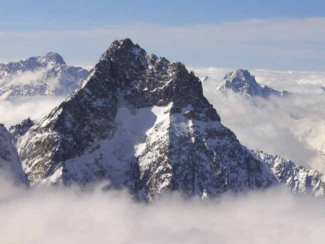
Physical Feature #2
A photo of the Pic La Selle. This is the highest summit in Haiti at a total of 8,793 feet above sea level.
Sumrada, B. (2004). Aiguille du plat de la Selle... [digital photograph]. Retrieved from (http://www.summitpost.org/aiguille-du-plat-de-la-selle/70179)
A photo of the Pic La Selle. This is the highest summit in Haiti at a total of 8,793 feet above sea level.
Sumrada, B. (2004). Aiguille du plat de la Selle... [digital photograph]. Retrieved from (http://www.summitpost.org/aiguille-du-plat-de-la-selle/70179)

Physical Feature #3
Lake Azeui is the largest lake in Haiti and is also a border in between Haiti and the Dominican Republic. This was where the indigenous Taino people lived when Columbus discovered the land in 1492.
Lake Azeui [digital photograph] (2014). Retrieved from (http://www.hougansydney.com/landmarks-of-haiti/lake-azeui)

Physical Feature #4
Island La Gonave off the western coast of central Haiti. Islanders in have faced hardships including drought and illness (cholera outbreaks). Recently, there has been support of non-profit and foreign aid groups to help dig wells and there is talk of making this island a tourist destination.
[La Gonave digital photograph]. Retrieved from (http://www.haitiobserver.com/blog/la-gonave-government-in-talks-to-develop-island-for-tourist.html)

Physical Feature #5
Île de la Tortue or Tortuga Island is an island off the northern coast of Haiti. It was discovered in 1492 when Columbus' ships crossed the "Windward Passage". It was on this island that a history of piracy took place. It is a very popular tourist destination as many films, including the Pirates of The Caribbean, were filmed here.
[Tortuga digital photograph]. Retrieved from (http://www.journaldunet.com/economie/magazine/acheter-ile/ile-de-la-tortue.shtml)

Human Feature #1
Shanty towns are common in Haiti with the majority of Haitian people living in poverty. Many are found in the capital city of Port-au-Prince and many of these towns faced great devastation in the earthquake of 2010.
Winter, D. (No Date). [Haitian Shanty Town Digital Photograph] Retrieved from (http://topics.nytimes.com/top/news/international/countriesandterritories/haiti/index.html)

Human Feature #2
In my physical features above, I showed you a picture of Island La Gonave. The photo above is a close up of what the island landscape actually looks like.
Moore, R. (No Date). [La Gonave Trash Digital Photograph]. Retrieved from (http://robinmoore.photoshelter.com/image/I0000rA.wjHG6R8g)
In my physical features above, I showed you a picture of Island La Gonave. The photo above is a close up of what the island landscape actually looks like.
Moore, R. (No Date). [La Gonave Trash Digital Photograph]. Retrieved from (http://robinmoore.photoshelter.com/image/I0000rA.wjHG6R8g)

Human Feature #3
This is a photograph of Sans-Souci Palace, meaning "carefree", in Milot, Haiti. This palace once housed the king, King Henri I, and Queen Marie-Louise, of Haiti and was finished in 1813. An earthquake destroyed a large portion of the palace in 1842 and it was never rebuilt. Today it carries the title of National History Park - Citadel, Sans Souci, Ramiers.
Kaupp, R. (2006). Palais de Sans-Souci [Digital Photograph]. Retrieved from (https://www.flickr.com/photos/le_korrigan/1081315321/)

Human Feature #4
The Grand Cimetière of Port-au-Prince is a site specific to Haitian culture and life. Colors, words, and imagery used on the graves of the deceased translate to great artistry and architecture. When the earthquake hit in 2010, many structures in the cemetery were destroyed. Many of those that lost their lives in the earthquake were not buried here, but rather in open mass graves.
Turnley, P. (2010). The Grand Cimetière of Port-au-Prince [Digital Photograph]. Retrieved from (http://theonlinephotographer.typepad.com/the_online_photographer/2010/02/haiti-between-death-and-life.html)

|

|
Human Feature #5
Above are two pictures of Haiti's Iron Market. The Iron Market was structure was initially built in France and was intended to be a railway station for Cairo. It was decided that it would be shipped to Haiti in the 1890s and it stood strong until the earthquake in 2010. In 2013 the market was rebuilt, complete with solar panels (left). The market has many products from produce, dry goods, clothing, and other products.
Baucher, J. (2013). The Iron Market Roof [Digital Photograph]. Retrieved from (http://www.bbc.com/news/in-pictures-20971898)
Baucher, J. (2013). Inside The Iron Market [Digital Photograph]. Retrieved from (http://www.bbc.com/news/in-pictures-20971898)
Biodiversity in Haiti
When we think of conservation in Haiti we might think about preservation and quality of human life, as we are aware many Haitians are faced with the hardships of poverty. However, it is important to remember that the citizens of Haiti are connected to the land and all that share the country, flora and fauna included. Haiti has the second most diverse ecology in the Caribbean (Convention on Biological Diversity, Biodiversity Facts). There are currently many efforts to preserve what is left of their land.
Many Haitians live in rural areas in small communities and have a strong connection to their surroundings as it is depended on so heavily. Unfortunately, many Haitians were forced into rural areas after the earthquake in 2010. Because there are few jobs in these areas, those in need of work turned to cutting down surrounding wooded areas in order to get what money they can. In turn, this leads to landslides and flooding ultimately putting their lives and communities at risk (Davies, 2010). It is also know that there is less than 3% of forested land left in Haiti, with more disappearing due to agriculture ventures but with little success (Saving Unique Biodiversity in Haiti, 2010).
Organizations like Durrell Wildlife Conservation Trust, Societe Audubon Haiti, Birdlife International, and The Zoological Society of London have partnered with the country and rural areas with plans to rebuild. The Societe Audubon Haiti has created jobs for individuals living in the Massif de la Hotte region, a region largely affected by deforestation (Davies, 2010). By creating nurseries in the community, this creates jobs while at the same time promoting conservation and rebuilding of the land.
On another note, the Massif de la Hotte region holds more endangered species than any other area in the world, however it is not a protected area (Davies, 2010). In addition, many of these species are endemic and hence not found in anywhere else in the world. The Hutia, a tree dweller with looks similar to a guinea pig, and the Solenodon, similar a giant shrew are two of the endangered species that are only found on this island. Those involved in these projects have a very positive outlook on what the future holds for Haitians and the diverse ecology of the country. There is lots of hope for a sustainable future of this country.
Works Cited:
Davies, C. (2010, September 10). Haiti's Fragile Ecosystems Facing Disaster. Retrieved November 17, 2015, from http://www.cnn.com/2010/WORLD/americas/09/10/haiti.biodiversity/
Haiti - Country Profile. (n.d.). Retrieved November 20, 2015, from https://www.cbd.int/countries/profile/default.shtml?country=ht
Saving unique biodiversity in Haiti. (2010, March 2). Retrieved November 17, 2015, from http://www.durrell.org/latest/news/saving-unique-biodiversity-in-haiti/
Société Audubon Haiti : Haiti Audubon Society | Conservation. (n.d.). Retrieved November 17, 2015, from http://audubonhaiti.org/program/conservation/
The Encyclopedia of Earth - Haiti. (2012, March 5). Retrieved from http://www.eoearth.org/view/article/153235/

Massif de la Hotte, Haiti

The Haitian Solenodon. Endangered.

The Hutia. Endangered.
